

I wanted to share photos of our New Year's travel to the land's end - на краешек земли, as I call it.
We do a lot of road trips. Practically every weekend we go exploring our amazing state which has so much variety (4 different climate zones, to begin with). There is probably not enough time in our whole life to really get to know every bit of it, and we do have quite a few favorite places where we return regularly, but we also love discovering new-to-us corners of Washington (with occasional trips to beautiful neighboring Oregon). This time, it was a trip to a new place, and literally a corner - the most Northwestern corner of the contiguous United States.
Please note: many photos in this post.
Bonus: you don't need to fasten your seat belts or wear your hiking boots to start your trip.

To get to this land's end from our place, there are two most logical ways - via Tacoma Narrows Bridge or via ferry from Seattle. On the way there, we drove via Tacoma's famous bridge (read why it's famous in this Wiki article). It always looks impressive, but especially against blue sky. Now we are on the Kitsap peninsula, which is separated from the Olympic Peninsula (our destination) by Hood Canal. To cross the canal, we use another bridge. Now we are very close to the biggest town on the whole Olympic Peninsula - Port Angeles (population a little over 19,000). The harbor on which the city is located was named by a Spanish explorer in 1791, and the whole name sounded like this:
Puerto de Nuestra Señora de los Ángeles (Port of Our Lady of the Angels).
WOW! Our ancestors appreciated fancy names like that, didn't they?

Winter and Summer 2014 - almost the same spot.
From the lookout tower, you can see the Olympic mountains, the city, the port with ferries coming and going to Vancouver Island, Canada (1.5 hour trip - and a bit of a drive to meet Shawna, which I definitely want to do one day), the Coast Guard located on Ediz Hook, a 3 mile long sand spit, and the third tallest mountain in Washington State - Mount Baker.

Mount Baker (North Cascades), elevation 10,781 ft or 3,286 m

The weather was rather brisk, and our walk was also rather brisk. I was happy to have all my layers on (I guess not all of my inner Siberian is lost yet!) - tank top, turtleneck, wool sweater and wool coat topped with a beanie and a long scarf (I think I even had tights under my jeans!). Another fun sartorial bit. I did not think much about my outfits while getting ready for our trip. I wanted to stay warm, as I knew we were about to spend a lot of time walking and hiking on our mini-break. I just threw in a few of my favorite things, and only later realized that they sort of all go together, without my trying. It was quite satisfying to realize that.


I love murals - these beautifully depict the history of the land and people.
We rented a cozy cabin on a lake in the mountains, 15 minutes from Port Angeles. It was such a serene retreat to come back to after a day of exploring.


There was just a touch of snow in the mountains, but nothing by the sea. One full day we dedicated going to the land's end. It's a two hour car ride one way. We took 101 and 112 - both are beautiful roads with gorgeous mountain scenery, the latter offers some amazing Strait of Juan de Fuca views as it goes along the shore.


Cape Flattery ahead - our ultimate destination.

There are wonderful photo opportunities, especially if you travel on a warm sunny day - mountain streams, ponds and little rivers, log cabins, wild animals and birds, trails etc. You will see a few small communities, not too many, here and there. Indians have lived on this land for millenia, and once you reach Neah Bay, there is the Makah Indian Reservation and a big museum of the Makah Tribe. It's open till 5 pm, so plan ahead - we did not have enough time to visit the exhibit, as it was getting dark early, and the road back is quite adventurous and exhausting for the driver, but we were greeted very warmly and even offered the chance to have our packed lunch in one of their classrooms as it was freezing cold and windy outside.


Finally, after a long travel and a short stop at the museum, we arrived at the head of the trail which leads to the most northwestern point. or the lend's end. The trail is not very long, somewhere between 1/2 to 3/4 of a mile long, but quite bumpy. It is not suitable for handicaps, strollers or people with weak knees or back problems. I am not in a great shape, and it was a bit challenging for me. Justin, with his weak knees, was not able to go to the very end of it, the most challenging part. (My parents though were climbing like it was not a big deal at all!) The enhanced trail is partly boardwalk, partly other types of "pavement" like stumps - you can see in the photos below. They do not recommend to step from the trail as there are wild animals like cougars living in the forest. Someone leaves walking sticks for those who need extra support at the head of the trail.

It was surprisingly warm and peaceful once we got on the trail. Such a serene place. The views, once you reach a few viewpoints, are breathtaking, and my words are too poor to describe what amazing feeling you get when you stand on the land's end. It's the end, but it's also a beginning, as every end is... It was like this thousands, millions of years before you, and will be long after you are gone. And being born and raised in the middle of one huge continent, have you ever dared to dream to reach the very end of another one? It was a magical way to celebrate the end of one year and beginning of another one, with dearest people, who came such a long way just to be with us...


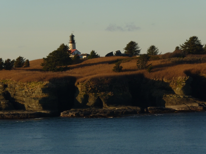
The Cape Flattery lighthouse was built in 1854 on the tiny Tatoosh Island. There is no other way to get to it, but by boat, and the lighthouse is automated for easier maintenance. It's operated by the US Coast Guard.
About the name Flattery - doesn't it strike you as an odd one? Apparently,


On the way back home, we revisited Port Angeles once again, took a nice long stroll along the Waterfront trail which I also can heartily recommend as it is a very easy, flat surface (partly paved), good for both walking and biking. You can watch helicopters and boats, or a huge variety of waterfowl, whatever suits your fancy.


Drive up to the Ediz Hook the 3 mile long sand spit - it's quite interesting, I can't remember ever driving through a working factory (manufacturing paper) on both sides of the road, then enjoying beautiful sandy beach and wild marine life (we spotted sea lions there!), and on the very end of it there is the Coast Guard station, as I mentioned before. There were also a lot, and I mean a lot of cats, pretty well fed, not afraid of people, just leisurely walking on the beach. Quite a unique spot. And of course, a gorgeous view of Port Angeles nested on the peaceful bay and covered by the magnificent Olympics, such a beautiful natural setting, I could spend hours just looking at it.


We took a "short cut" on the way back ("only" 300 km vs. 375 km when we went via Tacoma) - ferry from Bainbridge to Seattle. The city greeted us with its lights and one of the new additions to the skyline, the Great Wheel opened in 2012. Then we hopped on I-5, about half an hour - and we were home. It's hard to believe that just one day earlier, we were there, on the land's end. One of the many land's ends of our beautiful world.

Photos by Justin, my father and myself.
With this post, I've added a button to the upper panel for Culture & Travel, which allows you to view all of my posts related to these subjects (exploring theater, museums, festivals, cities and villages, parks, etc.).
I'm wearing my colorful beanie and scarf by Lane Bryant, just in time for Sacramento's Share-in-Style: Scarf and Rosy's here. See you there!
***
What a lovely day trip. I do love a day trip or any road trip and this looks so much like home! At first, when I read your title I thought you had purchased a nice cape from the Land's End Cataologue. Hah! After you take the ferry it is about a three hour drive to get to me, but you will probably want to stop in Chemainus to see the murals so that means it will take you longer. I would LOVE you to visit me, but if that doesn't happen soon we will perhaps meet up in Vancouver this summer. Or sometime we could even meet in Victoria. That would be cool too. Or we could do all of it! Why not!
ReplyDeleteGreat idea to make a button for your trip photos. Your photos and travel stories are always such a lovely vicarious vacation for your readers.
You look adorable in the scarf and hat! Great colours for you! xoxoxo
Very beautiful trip! I love day trips-- they are my favorite! Наташа, у тебя такое милое пальтишко -- цвет очень классный. Я все не могу найти себе пальто интересного цвета (черное и красное у меня есть). So happy for you that you have a chance to spend time with your parents. Missing mine so much...
ReplyDeletegorgeous trip!
ReplyDeleteyou guys really have plenty of landscape!!!! enviable landscape!
if i lived there i would run around in woods and on beaches 7/24 :-) ahh - that snowy mount baker!
your travel look is fab, happy colors and cosy, all what one need! i have a "hiking trip pile" in my closet, if a tour is in the cards i just can grab it, even in the dark.
thanks for this beautiful post!!!!!
xxxxxx
What a beautiful part of the world you live in, Natalia. So diverse, so much to see and enjoy. I confess to being an urban chick through and through, but I can appreciate the stunning scenery and vistas in your wonderful photos, and even I like to get out into the natural environment every now and again! How lovely to see you all enjoying the experience of exploring this area together. We all need a break from the routine and our own four walls, don't we, and this looks like the perfect trip to recharge the batteries, and the soul! xxx
ReplyDeleteWOW! Thank you for a trip. I love the photos. My favourite are the ones with the lighthouse. Amazing views and truly awesome you could share this beauty with your family.
ReplyDeletexxxxx
Lovely photos Natalia. What a quality family time that was and you look so warm and comfy in that beanie and scarf. xo
ReplyDeleteYou can be my personal travel guide! I love the fact that you've included a tab at the top so I can review these posts for ideas of what to do. I read these and often ask myself, "why is it that we don't do a lot of exploring?" and part of the challenge is getting my husband in the car for a road trip. His arthritis makes it difficult for him to sit still. But there is still a lot of things to do within an hour's drive in this great state.
ReplyDeleteYou and I will still have to meet possibly in the spring when things dry out for a hike down to Snoqualmie Falls. I'm really itching to do it because it's been so long.
Beautiful scenery, looks very familiar to me, too (i.e. very similar to where I'm from...). And you're right: your outfit does come together quite nicely.I guess that's the beauty of a well curated wardrobe: everything can be mixed and matched.
ReplyDeleteI love these wonderful pictures. Road trips are a great way to spend weekends. Looking forward to seeing more pictures.
ReplyDeleteJasmine ♥
fabulous post and fabulous pics!, love that you share your excursions with us, awesome landscapes!, and so cute that your parents are enjoying this with you!!
ReplyDeleteyou look cozy and colorful, such a wonderful thing when your outfit just come together easily and so nicely!, such beautiful colors!
besos
I so enjoy your travel photos and a glimpse of your part of the world. A great trip to share with your parents, creating so many wonderful memories of time spent together. You all look warm and toasty and dressed for the weather, no doubt lots of practice. I often feel if we are born and bred in one place we don,t appreciate the beauty around us.
ReplyDeleteWonderful pics, dear Natalia, so warm and caring close to your parents. I could do with a big hug from you right now.
ReplyDeleteThank you sooooooooooooooo much for sharing your style
Besossssssssssssss
XXXXXXXXXXXXXX
My goodness what a beautiful part of the world you live in! isn't it incredible? you have this almost on your doorstep albeit a 2 hour drive - it's wonderful to breathe nature in and see her in all of her glory, certainly good for the soul and you had your beautiful family there too - I love the names of places 'Cape Flattery' is rather beautiful, in the UK we have some bonkers names for places, for example 'Spittle' is not far from me and also a pub called 'bird in th'and' x x x
ReplyDeleteOh the Pacific Northwest. I do miss it so. These are beautiful photos. And I love the idea of taking a photo in the same spot at different times of the year. You are looking as sweet as ever.
ReplyDeleteNataliam
ReplyDeleteWhat a wonderful trip, how incredible to transverse so much land and see nature in her glory. Cape Flattery is lovely, the photos are stupendous, I love the idea, and the photos of, staying in a cozy cabin. You captured shots that I will want to revisit, the water and snow capped mountains, the happy smiles on you and your family,
I do love the scarf and matching beanie, too, and the Olive coat...
Fabulous, thanks for sharing them with us. !
xx, Elle
http://mydailycostume.com/
Snowy mountains...my favourite!
ReplyDeleteI remeber living in that beautiful part of the world, in Vancouver. How I would love to join you all this Summer.
Thanks for this gorgeous touf :-) xo JJ
It's time to vote on Share in Style, dear friend.
ReplyDeletethere is too much beauty in this post for me to soak up at once...I will be forced to come back...really amazing views:)
ReplyDeletep.s. really cute scarf and beanie!
http://modaodaradosti.blogspot.com/